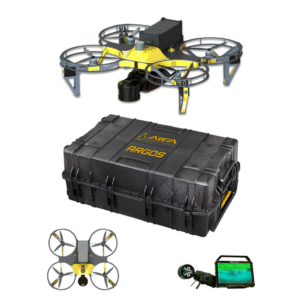
ARGOS is an autonomous drone designed for inspection and mapping in indoor or GNSS-denied environments, including complex, confined, or high-risk scenarios.
Its compact size, carbon fiber frame, and integrated propeller guards ensure high safety, stability, and reliability even in tight or unstructured spaces.
The system integrates the Nexys Pro LiDAR SLAM sensor by Exyn Technologies, enabling rapid capture of accurate, georeferenced, colorized 3D point clouds in real time.
Nexys Pro features a HESAI XT32M2X sensor (220° FOV, up to ~1.9M pts/sec, ±1 cm accuracy).
ARGOS can also be equipped with four high-resolution RGB cameras (120° FOV) for detailed inspections and 360° imaging.
Industries:
- Mining
- AEC (Architecture, Engineering & Construction)
- Geospatial
- Oil & Gas
- Logistics and large industrial facilities Job
Titles:
- Surveyor / Geomatics Engineer / Architect
- GIS Specialist / Surveying Technician
- Mining Engineer
- HSE Manager (Health, Safety & Environment)
- Project Manager (Construction & Infrastructure)
- Asset Integrity Manager
How is it making an impact?
ARGOS is an advanced 3D mapping solution designed to significantly reduce data acquisition time, enhance operator safety, and improve operational efficiency in complex or hazardous GNSS-denied environments.
It is used, for example, in the surveying of underground mines, tunnels, industrial plants, and production facilities, where it enables repeatable autonomous missions for frequent asset monitoring.
In large industrial sites, it can be deployed for periodic mapping activities (daily or weekly), integrating with other digital systems to support digital twin workflows, predictive maintenance, and advanced infrastructure management.