September 7-9, 2027  •  Caesars Forum  •  Las Vegas

Phoenix LiDAR Systems

MiniRANGER-3

What is it?

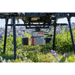
The Phoenix LiDAR Systems MiniRANGER-3 stands out as one of the few LiDAR solutions on the Blue UAS framework, offering a combination of compliance, flexibility, and performance. Designed for multi-platform use, it seamlessly supports UAV, mobile vehicle, and backpack-based data collection, enabling teams to capture high-quality data in virtually any environment. This versatility allows organizations to standardize operations with a single, NDAA-compliant system while scaling operations across diverse applications without sacrificing accuracy or efficiency.

Who is using it?

Survey and engineering firms are adopting the Phoenix LiDAR Systems MiniRANGER-3 for its survey-grade precision and cost efficiency. As an NDAA- and Blue UAS-compliant system, it removes regulatory barriers while delivering accurate data for mapping and design. Its multi-platform capability (UAV, mobile, backpack) lets teams maximize one system across projects, improving ROI and turnaround times.

How is it making an impact?

The MiniRANGER-3 is making a real impact by combining NDAA and Blue UAS compliance with a 300 kHz pulse rate and 2–3 cm accuracy. This allows firms to confidently capture dense, survey-grade data in regulated environments while maintaining speed and efficiency. The result is faster project delivery, reduced rework, and reliable data that meets strict industry and government standards, making it ideal for construction, utilities, rail, open-pit mining, agriculture & forestry, and oil & gas applications.