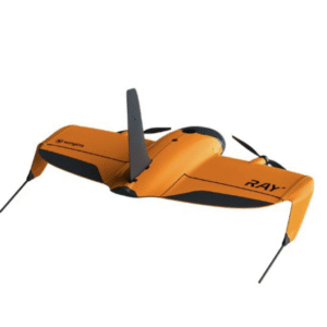
WingtraRay is a complete drone surveying system. From flight planning to CAD and GIS-ready outputs, it‘s built for speed, accuracy and ease of use, so you can focus less on setup and more on results that move your projects forward. WingtraRay combines all devices and software into one seamless flow. Share maps and data with a click. No massive file transfers or external hard drives— just send a link. Clients and teams can view and comment on surveys directly in their browser. WingtraRay is built to American standards, trusted globally—enabling compliant, reliable and safe drone operations. WingtraRay can fly up to 1360 acres 30x faster than terrestrial methods, 6x faster than multirotor drones and 40% faster than the Wingtra Gen2.
Who is using it?
Urban Planning and Land Management
Mining and Metals extraction
Construction and Infrastructure
Agriculture
Environmental Monitoring
US Government Agencies
How is it making an Impact?
Large-Scale Topographic Surveying: Efficiently mapping hundreds of acres to create high-resolution orthomosaics, DSMs (Digital Surface Models), and DTMs (Digital Terrain Models).
WSP uses Wingtra’s LiDAR technology to map large-scale infrastructure, such as highways and bridges. The WingtraRAY allows for mapping active sites and roads without requiring site shutdowns, thanks to its integrated safety features like the parachute add-on and obstacle avoidance. By combining RGB and LiDAR data, WSP can generate highly accurate Digital Terrain Models (DTMs) even in heavily vegetated areas. This is critical for site planning and drainage analysis in complex terrains.